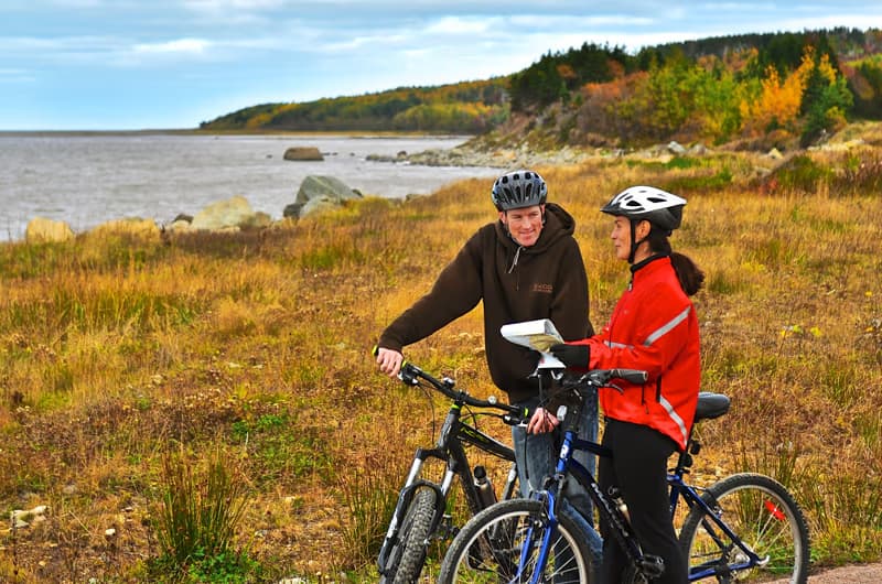
Ceilidh Coastal Trail (part of Celtic Shores Coastal Trail)
Length : 22 km (13.75 mi) – Canso Canal to Chisholm’s Brook, Long Point (linear) Cell Service : Yes Dogs Permitted : On Leash Trail Surface : natural, beach cobble, hard surface, gravel The Ceilidh Coastal Trail section of the Celtic Shores Coastal Trail begins at the entrance to Cape Breton Island, at the Trans Canada Trail Pavilion and Trailhead Kiosk beside the Canso Canal. The first kilometre of this 22-km (13.75-mi) multi-use trail is gravel-surfaced and single track, before entering a 2-km, hikeable tide-washed section. This section is “hike a bike”, but the scenery is amazing with the Strait of Canso on one side and beautiful Long Pond on the inland side. Cyclists are recommended to access the trail in Troy along Route 19. The next 4.5 km (3 mi) of the trail is undeveloped rail bed. Though the surface is a bit too rough for cyclists, its worth the walk, as you will often have a front row view of ocean-going tankers, tugs, sailboats, yachts and barges approaching the Canso Canal locks. Depending on the season, you may see people or the occasional eagle fishing along the shoreline. The next 1.5 km (1 mi) of trail is a gravel-surfaced double track, followed by 2.5 km (1.5 mi) of paved trail (recycled asphalt). The final 11 km (7 mi) is gravel trail, double track. In addition to the stunning coastal views, the trail features wayfinding signage and interpretive panels, which outline the history and culture of the surrounding communities. Trailhead : After crossing the Canso Causeway at the entrance to Cape Breton, you’ll see a parking area and the Trans Canada Trail Pavilion and Trailhead Kiosk on your left. Walk the length of the parking lot and continue along the right side of the chain link fence surrounding the Canso Canal property. The trail continues along what is known as a ‘parallel bar,’ which is a long, thin ribbon of sand, gravel and rocks. Cyclists are recommended to access the trail from the Troy Station Trailhead Kiosk along Route 19. 71 Hwy 104, Port Hastings. Troy Station Trailhead: 45.691553, -61.439462 (civic: 1020 Route 19)
Share a star rating, a quick note, and a photo or two to help future travellers.
Sign in to write a reviewVisitor photos
Sign in to add a photoLoading photos…
You might also like

St. Peter’s Canal National Historic Site
Visit St. Peters Canal, where the Atlantic Ocean joins the sparkling Bras d’Or Lake. Enjoy beautiful water views and out
★★★★★ (197)
Point Michaud Beach Provincial Park
Point Michaud Beach Provincial Park on Cape Breton Island (1 km / 0.5 mi east of Point Michaud, 3796 Hwy 247) is an exce
★★★★★ (164)
Jerome Point Lighthouse
The Jerome Point Lighthouse was originally constructed in 1883 as a wooden, square, pyramidal tower of almost eleven met
★★★★★ (87)